Posts

Mount Maroon Climb via Cotswold Track

Image
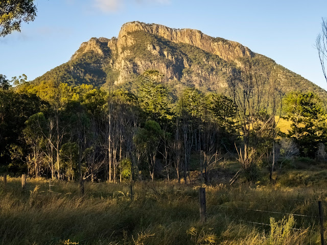
  The east face of Mount Maroon lit up by the morning sun.  This is a relatively short climb to the summit (966 metres), but it will give you a good work out as it is straight up.  Double click on the photos to see them in full screen. The most direct summit route is via the ridgeline on the left of the photo.  You cut across to the right at the base of the exposed cliff and up through the gorge, keeping to the left hand track as you come into the old campsite.  The actual summit is to your left and the track to the right leads you up to the natural ampitheatre on the north eastern side of the mountain. There are other longer routes to the summit (i.e. caves route) and plenty of scrambling to be had if you want to burn off some more energy exploring this mountain. Take your time and enjoy the views along the way. The climb itself isn't technical, there are parts you will need to lift yourself up and none of it is very exposed.  Just lots of rocks and not so fun on the way down for

Routeburn Track - Routeburn Shelter to Routeburn Falls Hut

Image
Day 1 of the Routeburn Falls hike started with a beautiful drive up from Queenstown up through Glenorchy to the Routeburn Shelter.  If you have a chance to spend some time around Glenorchy, try  horse riding up through the Glacial Valley! The trails are well defined and the first part of the hike to Routeburn Flats is easy going uphill. The clouds will start to lift as the day progresses.  You are soon walking beside a beautiful mountain stream. You will soon cross a tension bridge - there are lots of these in NZ and they are very well built!  This is when you start realising you are in "Narnia" (for C.S. Lewis fans). You continue to follow this stream out onto the Routeburn Flats (play sound of music soundtrack here). Your target for the night is at the top of the falls - in the saddle of the following photo. If you wanted, you could camp or stay at the Routeburn Flats Hut which has a pretty amazing outlook. The next section of

The Routeburn Track - New Zealand

Image
The Routeburn Track is a spectacular 3 day hike on the South Island of New Zealand. The track is 33 kms in length and is generally accessed via Glenorchy and finishes on the Te Anau side of the range, though you could easily do this in reverse. If you are doing this walk point to point, you  will need to organise a bus transfer or car shuffle.  If there is more than one of you doing the walk, then the car shuffle option through a third party works really well and is cost effective. The track is really well sign posted so you don't need to be constantly looking at your GPS unless you have destination syndrome - but this hike may not be for you! You could do this track in less time but why would you.  The first two days of this hike were amazing - an option I would consider is to spend a couple of nights at Routeburn Falls Hut and spend more time exploring the area between Routeburn Falls and the Harris Saddle and then walk back out to the Routeburn Shelter which w

Cedar Creek to Greenes Falls

Image
This hike is just over 7 kms return from the Car Park at the end of Cedar Creek Road.  There is a fair bit of rock hopping and scrambling involved and lots of beautiful waterfalls and rain forest to explore.  With taking photos and not rushing the walk, it took around 4 hours up to the top of Greenes Falls and 3 hours return to the car park - noting that I wasn't pushing the pace as the rocks were very wet and slippery from rain on the previous day and I was taking photos. Just to clarify I use the terms hike and walk - but this is a climb/rock scramble and is steep in places.  Do not under take this if it is wet, has been wet or is likely to be wet.  These rocks are very slippery when wet! Take off from the carpark and head up to the top of Cedar Creek Falls. Keep heading up the creek past Black Creek on the left and the retreat center on the right, passing a number of beautiful rock pools until you get to the junction of where Love Creek joins Cedar Creek on th